Ready for some of the best hikes in Norway? Umm, heck yeah you are!
Because I see you over there with your Merell boots and hiking poles at the ready. You’re also quietly nibbling away at some beyond delicious trail mix while visions of next-level gorgeous fjords in Norway seamlessly dance through your head.
And that makes sense since Norway is known for being one of the most beautiful countries in the world…period.
That’s why, there’s really no better way to experience the jagged mountain ranges, enormous glaciers, awe-inspiring fjords, and rugged coastlines that have made this Scandinavian country famous than with this hella epic list of the best hikes in Norway.
Yup, it’s brimming over with expert advice and secret insider tips that will help you plan a super outdoorsy, very Norwegian vacay.
Because every time I go back to Norway (and I’ve been a lot), two things happen.
- I find even more amazing Norway hiking trails to explore.
- I’m left wondering how quickly I can return.
So, go on, take a gander at this comprehensive Norway trekking guide and begin to understand this unique Norwegian travel phenomenon.
Because if you love the great outdoors even a little bit, then there really is no place on Earth quite like Norway.
Who knows, it might even be the IDEAL place to learn how to pee outside (FINALLY).
Dear wonderful, beautiful, and oh-so-amazing reader (Yup, I lay it on thick for my dozens of fans). Since I am incapable of making it rain money, there’s a high probability (like 99.999%) that this post may contain affiliate links. Please see my disclosure for more information. As an Amazon Associate, I earn a small commission from qualifying purchases.
Best Hikes in Norway in the South
1. Pulpit Rock (aka Preikestolen)

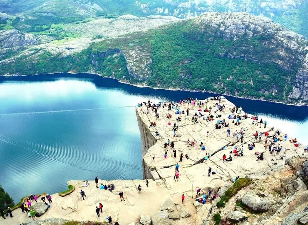
Even if you’ve never been to Norway, you’ve probably still heard of Pulpit Rock (aka Preikestolen) since it’s easily one of the most famous Norway hiking trails on this list.
And that makes a lot of sense since Pulpit Rock sits 604 meters (1982 feet) in the air and precariously dangles above the awe-inspiring Lysefjorden (it’s a fjord) below.
Now, because of the snow and the minimal amounts of daylight throughout the winter months, I would really only attempt this hike sometime between April and September.
It’ll also take you a little while to get here since the closest city to the trailhead is Stavanger. So, from here, you’ll need to drive about 23 miles (36.5 km) to get to one of the best hikes in Norway.
And while that doesn’t sound very far, the trip there will take about an hour and a half since you’ll need to hop on a ferry tha will take you from Stavanger to get to Tau.
However, once you finally do get to this epic Norway hiking trail, you’ll need to do a steep (bet well-marked), two-hour, 3.8 km climb to the rock itself.
Thankfully, the steepest parts of the climb are actually at the start of the trail, with the final ascent along a sometimes windy, granite rock and several exposed cliffs that take you out onto Pulpit Rock proper.
And unlike many places in the US, there won’t be any protective barriers or fences here. So, be careful and don’t take any unnecessary risks while enjoy the stunning, panoramic views from this gorgeous trail.
Pro Tip: If you’re really into hiking but can’t stand the crowds at Pulpit Rock, then here are some more of the best hikes in Norway that are in the Stavanger area – all of which are accessible from the Preikestolhytta parking lot.
- The Vatnerindane ridge circuit (two hours)
- Ulvaskog (three hours)
- The Refsvatnet circuit (three hours)
- Summit of Moslifjellet (three hours)
- Two-day hike to Lysebotn
Length: 8 km (5 miles round trip)
Difficulty: Easy/Moderate
Elevation Gain: 500 meters (1,640 feet)
Time to Complete: About four hours (with breaks)
2. Kjeragbolten hike

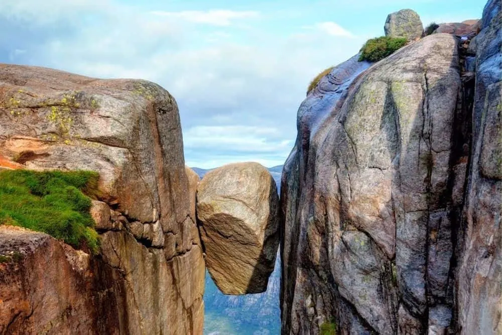
Real talk? Not only is the Kjeragbolten hike easily one of the best hikes in Norway, but you’ll enjoy seriously stunning views on the way to the top.
Plus, once you finally do get to Kjeragbolten, you’ll be able to nab a sweet, sweet photo of yourself standing atop the boulder pictured above.
Sadly though, this place isn’t a secret (not even a little bit) so you will have to wait in line to get the aforementioned picture. However, when it’s finally your turn, you can use a well-placed ring to step out onto the boulder. Trust me, stepping onto this giant rock is a whole lot easier than I thought it would be.
But, per usual, I’m getting a little ahead of myself. I mean, how do you even get here in the first place?
Well, that’s a great question and you have a couple of different options. You could either base yourself in Lysebotn, which is a 15-minute drive away, or do the 2.5-hour here from Stavanger (Most people do this and it’s worth it since the views along the way are lovely. FYI, there’s also a daily bus here from Stavanger in the summer).
Once you’re here though (type “Kjerag parking” into Google), you will have to pay 300 NOK to park at the lot in Øygardstøl, where you’ll also find some bathrooms and a restaurant.
From here, you can then start the actual hike. And what I love is that the steepest section is first, and features chains that you can use to help you climb up. So basically, if you can get through this section then you can complete the remainder of the hike.
The trail is also pretty easy to follow since there is a clear stone path with steps, making the route kind of hard to miss. Then, along the way, you’ll do an easy descent and then a second ascent which is pretty tough, although thankfully short.
Therefore, this is a good spot to rest before doing the final climb, which is the longest of the three. However, the good news is that once you complete this climb, the rest of the hike is easy and relatively flat by comparison. So you’ll have plenty of energy for photos, which are the perfect Norway souvenir.
Also, be sure to give yourself a bit of a rest before heading back since you will need to do a few climbs on the return trip. If you want, you can also use the chains here to almost repel down steep sections on the way back.
You know, just to help give your knees a well-deserved break.
Pro Tip: The Pulpit Rock hike is only about two and half hours away by car. Therefore, you could definitely do two of the best hikes in Norway while in the Lysefjord area. I would also only do this hike between June and September since it can be dangerous at other times of the year.
Length: 12 km (7.5 miles round trip)
Difficulty: Difficult (You should be in decent shape before attempting this hike. That being said though, there are flat sections in between strenuous ascents that will help give you a break. And no, small children should not attempt this hike. You should also come with proper hiking gear, in addition to a pack full of water, food, layers, etc.)
Elevation Gain: 800 meters (2624 feet)
Time to Complete: Between 6 and 8 hours.
3. Galdhøpiggen

Located in Jotunheimen National Park, Galdhøpiggen is actually Norway’s tallest peak and soars to more than 2469 meters (8,100 feet) in the air.
Thankfully though, there are a couple of different trails that will take you to the summit – all of which vary in difficulty – making this one of the best hikes in Norway that is also accessible to every type of hiker, regardless of their level of experience.
It’s also one of the most popular Norway hiking trails on this list since it’s not technically difficult and doesn’t require any advanced mountaineering skills to get to the top.
Plus, it’s surrounded by Styggebrean Glacier to the North, Svellnosbrean Glacier to the south, and Storejuvbrean Glacier to the West.
So yeah, the views of the surrounding landscape are next-level impressive from the summit and this is s great activity if you’re worried about your budget in Norway. And if you want to climb to the top yourself, you can always hire a guide or try one of these routes solo.
- Spiterstulen Route (this is the easiest route up) – This trail is a fairly straightforward 1400 m (4593 feet) climb. In total, it will take about 4 hours to get to the top and then about 2 hours to get back down. Most of the time, you’ll traverse across rock, with snow possible depending on the season. You also may have to go across small portions of a glacier near the summit, so crampons may be necessary, particularly if the ice is exposed.
- Styggebrean Glacier Route – This ascent begins at Juvashytta lodge and is the shortest route to the top since you’ll only climb about 600 m (1968 feet). However, when doing this route, you will have to cross Styggebrean Glacier. Therefore, a rope will be necessary in case snow hides any crevasses in the ice. But, once you get across the glacier, it’s an easy climb up a rocky ridge to the top. So if you want to do this route but aren’t experienced at climbing glaciers, then you could always hire a guide in Juvashytta.
- Geitsætre Route – Because this trail is a bit longer, it will help you avoid the crowds that sometimes inundate the area. It also starts at Geitsætre (in Leirdalen) and then continues along the Nørdre Illåe to the Nørdre Illåbrean Glacier. You’ll then traverse the Storjuvbrean Glacier and eventually hit the trail that begins at Juvasshytta.
- Ymmelstinden-Storjuvtinden-Galdhøpiggen Ridge Route – This hike is pretty difficult and really only meant for experienced climbers. But if you want to give it a try, you’ll start at Styggebrean Glacier, then ascend Ymmelstinden (2304m) and Storjuvtinden (2344m), and then finally make your way along the ridge and to the summit of the mountain. Basically, this is one of the best hikes in Norway that is ONLY meant for experienced climbers.
Pro Tip: The closest town to Jotunheimen National Park is Lom. And luckily for you, there are five different buses that depart daily from Oslo that will take you here. I would also recommend climbing in the summer since the weather is warm and the days are long. Just avoid visiting on a weekend since this mountain is insanely popular.
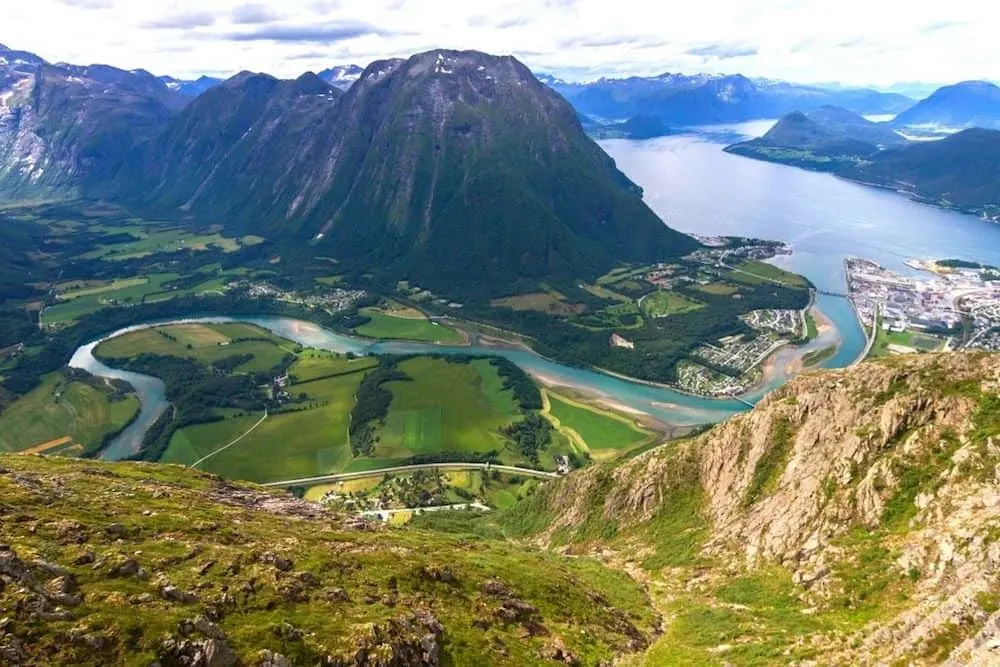
4. Romsdalseggen Ridge

Without a doubt, this is probably the most jaw-droppingly beautiful climb on this list of the best hikes in Norway. No really, if Lonely Planet said it (a la 2011) then it must be true!
But gorgeousness aside, this hike is not for the faint of heart. That’s because it is a strenuous, 960-meter ascent over rocky terrain that is closely followed by an arduous descent that features exposed trail sections – areas where you can use chains affixed to the rock to get through the steepest portions of the trail.
So yeah, definitely make sure you’re an experienced climber before attempting this hike up Romsdalseggen ridge. However, if you think you’ve got what it takes, then you can hop on a bus from the Norwegian Mountaineering Centre (Norsk Tindesenter) fpr 190 NOK per person and make your way the trailhead.
From here, follow the red Ts and make a moderate climb up Hestheia, where you can fill up your water bottle one last time. Next, turn west and make a steep climb up the mountain and onto Romsdalseggen ridge.
From here, the climb gets intense and VERY steep. But, all of your efforts will be handsomely rewarded with stunning panoramas of Trollveggen cliff, the Dalsida Mountains, Reinheimen National Park, and the Romsdalen Valley.
Next, you’ll turn right and make your way along one of the narrowest sections of the trail to Halsaskaret ridge. And although it’s steep, there are chains here to help get you safely to the highest point of the hike at Mjølvafjellet (1,216 meters).
Afterward, the path widens significantly and is followed by a gentle descent to Nesaksla, where you’ll find a nice little stone shelter to rest in if you need it.
You’ll then hit the final section of the trail which is intense and may require hiking poles as you make your way down to Rampestreken viewpoint – a place where you can go photo crazy and snap pics until you can snap no more.
Pro Tip: If you want to drive here, then you can park your car for free (langtidsparkering) just across the street from the train station (Isfjordvegen). From here it`s a short walk to Norsk Tindesenter where the bus departs from.
Length: 11 km (or a 7-mile point to point hike)
Difficulty: Difficult
Elevation Gain: 960 meters (or 3149 feet)
Time to Complete: This one will take between 8 and 10 hours to complete.
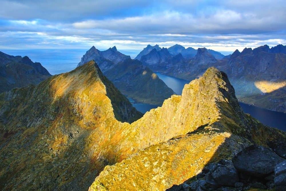
5. Besseggen Ridge

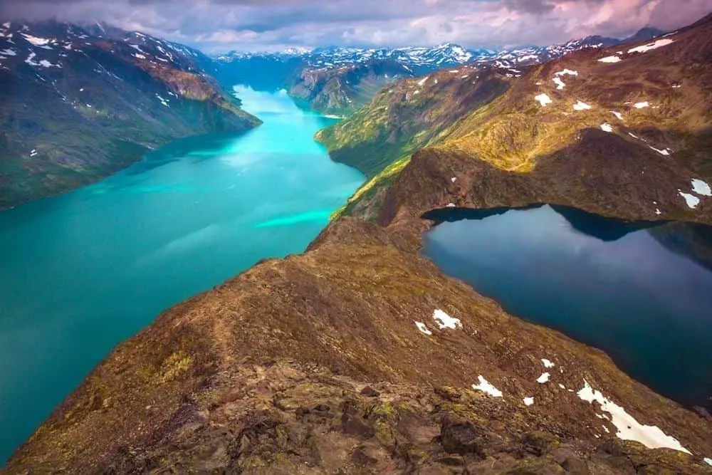
This is another one of the best hikes in Norway that also happens to be in Jotunheimen National Park – a climb that offers hikers stunning views of the surrounding mountains and the area’s many emerald blue, alpine lakes.
However, before starting this climb, you should know that most visitors tend to use this as a point-to-point trail between late June and early September.
That’s why, most visitors will take the ferry to Memurubu, access the trailhead here, hike to Gjendesheim, and then spend the night there since this is the easiest hike up the ridge.
Overall, the hike is pretty dang intense for the entire 14 km. Therefore, you will need to be in good physical shape before starting this climb.
You’ll also do some scrambling along the way and will hit the Besseggen Ridge about halfway through the hike since this natural feature is about one kilometer long and goes up 250 meters in elevation.
However, if you do this route and have a little trouble with the hike, you can always turn around at any time. Or, you can simply go to the viewpoint and admire the views of the Jotunheimen Mountains and Bessvatnet/Gjende lakes before heading back the way you came.
Alternatively, you could always hire a local guide to help you with this climb if you are unsure of your ability to complete this climb.
Also, like with most of the strenuous hikes on this list, always remember to come properly prepared with hiking shoes (with profile soles), waterproof layers, food, water, and a towel/swimsuit if you want to go for a swim in Lake Bessvatnet.
Pro Tip: This is a popular tourist destination and as a result, tickets for morning ferry departures from Gjendesheim fill up fast. So, definitely be sure to book your tickets in advance, online, for daily service between mid-June and mid-September. And if you decide to drive here, you can park at Reinsvangen (1.5 km before Gjendesheim) and then take a free shuttle bus to either the trailhead or the boat.
Length: 13.3 km (8.2 miles point to point trail)
Difficulty: Difficult
Elevation Gain: 1072 meters (3520 feet)
Time to Complete: Between 7 and 8 hours.
6. Trolltunga Hike

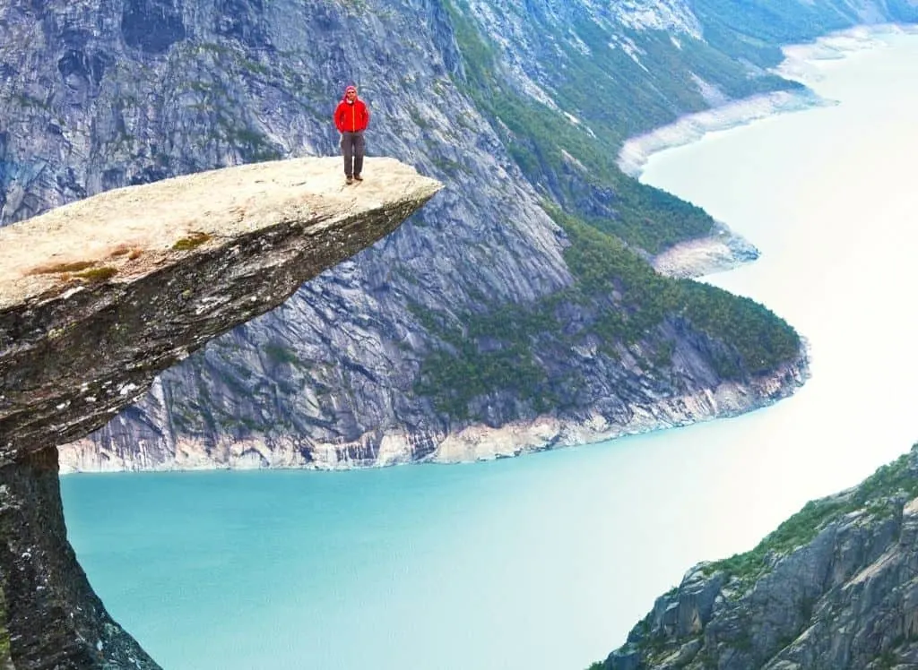
The Trolltunga Hike, or the troll’s tongue hike in English, is probably one of the most instantly recognizable, super famous hikes in Norway.
That’s because it is easily identified by a slender piece of rock that dramatically juts out into the air, right above the bright blue waters of Lake Ringedalsvatnet below,
However, to get to one of Norway’s most iconic geologic features, you’ll first have to get to the trailhead at Skjeggedal, which is about 13 km (8 miles) away from the town of Odda which is one of the prettiest towns in Norway.
Once here, you’ll find that from the parking lot, the trail is extremely well-marked with detailed information on how far you are from the summit.
However, to get to the top, you’ll need to endure an intense 27 km (17 miles) round trip hike that will easily take you at least 10 hours to complete (this obviously depends on how fit you are and how fast you move).
So, definitely come prepared with proper equipment, and be sure that you’re in decent shape since you’ll need to ascend a staggering 1100 meters (3,600 feet).
Yeah, I’m not gonna lie, the climb in spots is more than a little brutal. Although, you do get to admire Tyssestrengene waterfall along the way so that makes things a bit more bearable.
Also, since it’s a relatively long hike, it’s really only safe to do between May and early September, when there isn’t a ton of snow on the ground and when you have enough daylight to actually complete one of the best hikes in Norway.
Pro Tip: If you want you can definitely hire a guide for the climb. Also, be prepared to see tons of people at the top since this climb is definitely no secret. And if you continue a little further up the trail, you’ll also hit Preikestolen (Pulpit Rock). No, not THAT Pulpit Rock. This one is much tinier than the one near Stavanger but still a cool place to check out since you’re already here.
Length: 27 km (17 miles round trip)
Difficulty: Difficult
Elevation Gain: 1,100 meters (3,600 feet)
Time to Complete: Between 10 and 12 hours (with breaks)
Best Hikes in Norway in the Lofoten islands
7. Hermannsdalstinden

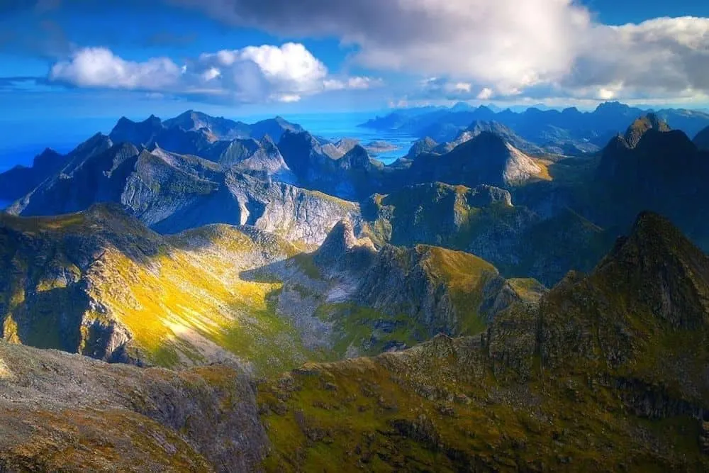
Just one of the many best hikes in Norway that can be found on the Lofoten Islands, the climb up Hermannsdalstinden is a grueling endurance test since you’ll be ascending the only 1000+ meter mountain in the region (FYI, this mountain stands at 1029 meters tall).
So, be prepared for a long, steep, sometimes slippery climb that is only meant for advanced hikers.
But, if you can somehow manage to make it through, then you’ll be rewarded (and handsomely) with stunning views of the many mountains and lakes that proliferate throughout this area.
However, to fully prepare for your climb, you’ll first need to decide which route you’re going to take to the top (FYI, I’d opt for starting in Forsfjord and exiting in Sørvågen). Your choices are:
- Sørvågen – This is the longer (9 km), hiking-only ascent that begins on the northern side of Lake Sørvågvatnet (the large lake in the middle of Sørvågen), right near a waterfall. You’ll cross a small bridge over the river and then start uphill. You’ll climb up, make your way past several lakes and ponds, can use chains to help you climb up steep and slippery sections of the trail. You’ll then have several trails to choose from so be on the lookout for small cairns to make sure you’re still on the right path. Summit Djupfjordheia and then climb back down to Munkebu hut, the halfway point. Go behind the building and to the left to continue descending down the trail. Turn right, between the two lakes, and continue on to hill 448. Summit the hill and then climb down along the right side of lake Krokvatnet. There are some short, but super muddy/ steep sections along the trail here, so be prepared.
- Forsfjord – This is the shorter (5.5 km) but a whole hell of a lot steeper route that meets up with the Sørvågen trail about halfway through (hill 448). Also, don’t attempt this climb on a rainy day and once you start, it’s extremely difficult to turn around. Now, to access this trail, you’ll need to take the Vindstad/Bunes ferry from Reine. From the pier, you can find the trail on the right, behind a giant power station (you’ll know you’re on the right track if you see red, painted rocks). Once on the trail, it can be hard to follow since it’s a bit overgrown. But, it’s a long, steep climb that eventually brings you to lake Tennesvatnet. Go right and climb hill 448. Once you summit, continue right and up towards Hermannsdalstinden. Descend to lake Krokvatnet and then use ropes to get through several steep and muddy sections. You’ll hit a small plateau and will want to go right before zig-zagging up the mountain and doing a final push up some loose rock to the summit.
Length: 18.9 km (11.8 miles, out and back trail)
Difficulty: Difficult
Elevation Gain: 1,932 metes (6,341 feet)
Time to Complete: Between 10 and 14 hours
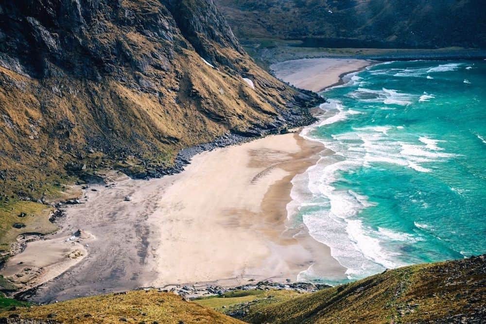
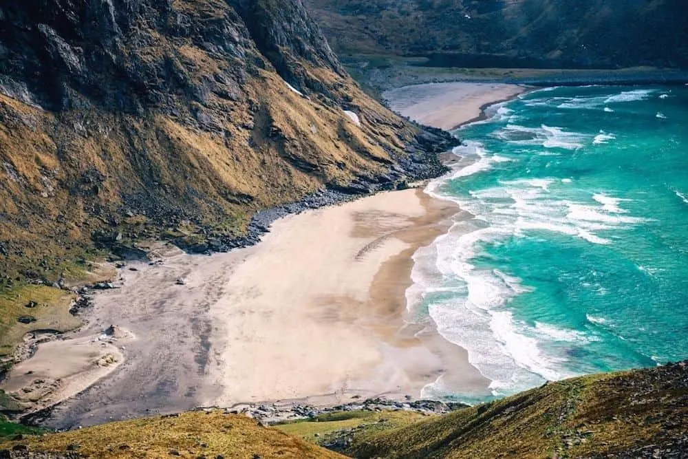
8. Ryten and Kvalvika Beach
If you’re not a hiking pro but are visiting the Lofoten Islands, then this is 110% one of the best hikes in Norway for you!
Not only will enjoy insane views of the many mountains, beaches, and fjords that this region is known for, but it’s a relatively easy (at least by Norwegian standards), climb up Ryten to the top.
And, added bonus? Once you get there you’ll marvel at stunning panoramas of the sandy beaches below. There’s also a little outcropping of rock here where you can take photos above the beach and feel like you’re at Trolltunga all over again.
You can even choose between a more direct route to the top or one that takes you through Kvalvika Beach (I’d opt for the second route), both of which are outlined below.
- Direct Route – To get here, you’ll cross over two bridges and then follow the signs towards ‘Yttersand.’ Continue past a turnoff for Fredvang, and go straight. You’ll eventually see a barn and the parking area should be just past it. From here, follow the trail through a meadow and bear right towards the valley at Innersand before beginning your ascent. Turn west, pass two lakes, and. continue to a rocky area where you’ll want to stay on the left side of the hill. Continue to the summit and enjoy nice views from the ridge on the left.
- Kvalvika Beach Route – This trailhead is directly across from the parking area and is pretty flat, although boggy, as you continue in between the two mountains. After about 40 minutes, you’ll hit the top of the pass and can then go down to the beach. It’s fairly steep and slippery when wet, so do be careful. Once at the beach (it’ll take about an hour), you’ll see a small creek on the right and this is where you can hop on the trail that will take you up and eventually flatten out at a local lake. Continue to the left and take the trail up the mountain and to the summit. You may lose sight of the trail along the way but will eventually hit a well-worn path.
Pro Tip: A lot of these trails are steep and rocky and get extremely slippery when wet. Therefore, I wouldn’t advise hiking on a rainy day.
Length: 8.7km (5.4 miles round trip, out and back trail)
Difficulty: Easy/Moderate
Elevation Gain: 955 meters (3,136 feet)
Time to Complete: Between 3 and 5 hours
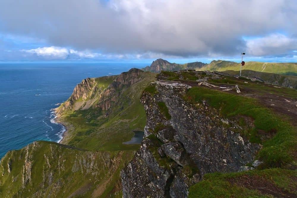
9. Svolvaer Fløya and Svolvaergeita

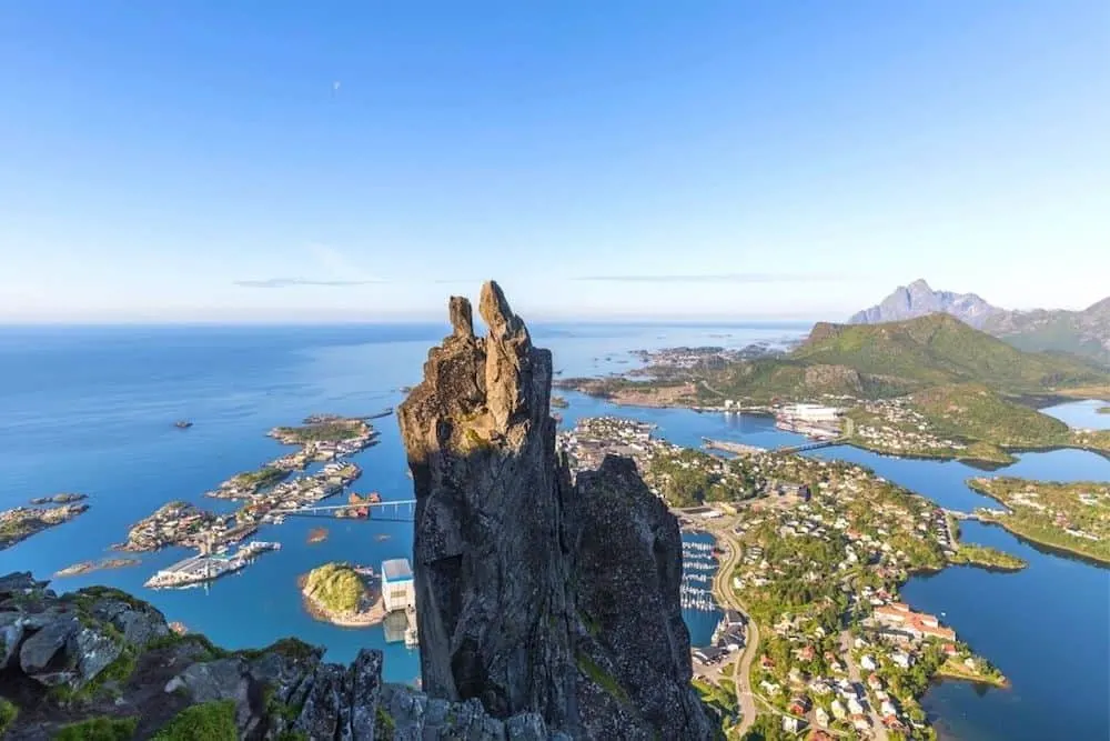
If you only do one hike in the Lofoten Islands, let this be it. Because a climb up Fløya is an absolute must if you’re in Svolvaer.
I mean, not only are the views insanely amazing, but if you’re into rock climbing, you can actually climb up Svolvaergeita (pictured here and known as “The Goat” in English) – making for the ultimate Norway hiking experience.
To access the trail, just park at the church in Svolvaer and prepare for a short, but challenging hike up this gorgeous mountain. The first part of the trail is easy to follow but steep AF. It then flattens out, becoming exceptionally muddy before you hit Djevelporten.
Continue up to Fløya along a cliff edge (the path gets really narrow here and pretty close to the cliff so you may want to walk parallel to the path instead) and once you’re near the top, you can either summit (this last little bit is challenging and really only suitable for VERY experienced climbers) or descend to a lower viewpoint where you can marvel at spectacular views of Svolværgeita, Djevelporten and all of east Lofoten.
Length: 5 km (3.1 miles)
Difficulty: Moderate
Elevation Gain: 620 meters (2,035 feet)
Time to Complete: Between 3 and 4 hours for the hike and then add on another 2 hours if you want to rock climb to the top of Svolvaergeita.
10. Munken

Want to understand what the Lofoten Islands are really all about? Then combine a hike up the summit of Munken with an overnight stay at Munkebu hut for the ultimate, outdoor experience.
Trust me, you’ll be able to fully immerse yourself in the almost otherworldly beauty of the Lofoten Islands while still remaining on the well-trodden path (literally) – providing you with easy access to help if you should run into any problems along the way.
Add in stunning views of the surrounding mountains and fjords and you easily have one of the best hikes in Norway.
So, if you want to tackle this intense hike yourself, hop on the trail on the northern side of lake Sørvågvatnet (right in Sørvågen and it’s near a waterfall) after parking your car on the west side of the lake.
Cross the bridge and go up the well-marked trail that will take you across varied terrain. You’ll climb up to Lake Studalvatnet, walk around a small bay, continue on a steep trail to the right (use chains to help you climb) and eventually level off at a boggy area near another lake.
You’ll then climb up a rocky hill, making your way towards the summit of Djupfjordheia before descending slightly to Munkebu hut and hitting the halfway point of the trail.
Continue past the hut and follow the most obvious trail (there are a ton of paths here) that takes you from the lake, up the rocks, and to the hill (if you’re heading downwards, you’re not on the right path),
Zig-zag up the mountain and when you pass several ponds, you’ll know that you’re almost at the top since the trail evens out before the final ascent to the summit.
All in all, it’s just a great hike for anyone with a wealth of hiking experience.
Length: 11 km (6.8 miles round trip)
Difficulty: Difficult
Elevation Gain: 797 meters (2,614 feet)
Time to Complete: Between 6 and 8 hours round trip.
11. Reinebringen

If you’re not a hardcore hiker but want to enjoy some of the best views in the Lofoten Islands, then this is the hike for you!
Because guess what? This is a short, easy climb up 1,560 stone steps that eventually take you almost to the top of, you guessed it, Reinebringen.
Yeah, the stone staircase isn’t totally complete yet so you’ll have to go the last little bit (50 meters) to the summit on your own (go right). There are also a TON of loose rocks here so be extremely careful.
However, due to its massive popularity (thanks, social media), this is one of the best hikes in Norway that you definitely won’t have all to yourself.
Therefore, try and get here either earlier in the morning or later in the evening so that you don’t have to deal with too many people.
You can also access the staircase on the western side of Ramsvik tunnel, although, parking can be a bit of an issue.
Therefore, try parking at Djupfjord viewpoint (it’s free and 1.3 km from the trail), Ytre Havn, Reine (1.8km from the trailhead and 50 NOK per day), and Reine Kultursenter (in the center of town and 150 NOK per day).
Pro Tip: Don’t do this hike when during winter or during the day in the summer since there is a ton of loose rock that could fall on you near the top.
Length: 2 km (1.2 miles round trip)
Difficulty: Easy
Elevation Gain: 448 meters (1,470 feet)
Time to Complete: Around 2 hours.
12. Horseid Beach
Hidden away among the rugged mountains of Moskenesøy’s northern coast is this long, isolated, and beautiful stretch of narrow beach.
However, this is one of the best hikes in Norway that you will have to take a ferry from Reine to get to.
Although, if I’m being totally honest, the additional trip on the ferry makes it a lot quieter than Bunes and Kvalvika beaches.
So yeah, I’m definitely not complaining.
Anyway, to get to the trail, you’ll need to take the same ferry that you would to Bunes Beach and just get off at Kierkefjord/Kjerkfjord instead.
Once at the pier, keep right and walk past the houses until you hit a stream with a sign that points to a small trail on the left. It’s slightly overgrown but you’ll slowly ascend upwards until the trail flattens right out at the top.
You’ll then continue down a steep muddy/rocky path to the actual beach. Yup, super easy peasy and just a nice place to relax while listening to the waves rolling in.
Length: 4.5 km (2.7 miles)
Difficulty: Easy
Elevation Gain: 200 meters (656 feet)
Time to Complete: Between 2 and 3 hours
Best Hikes in Norway in the North
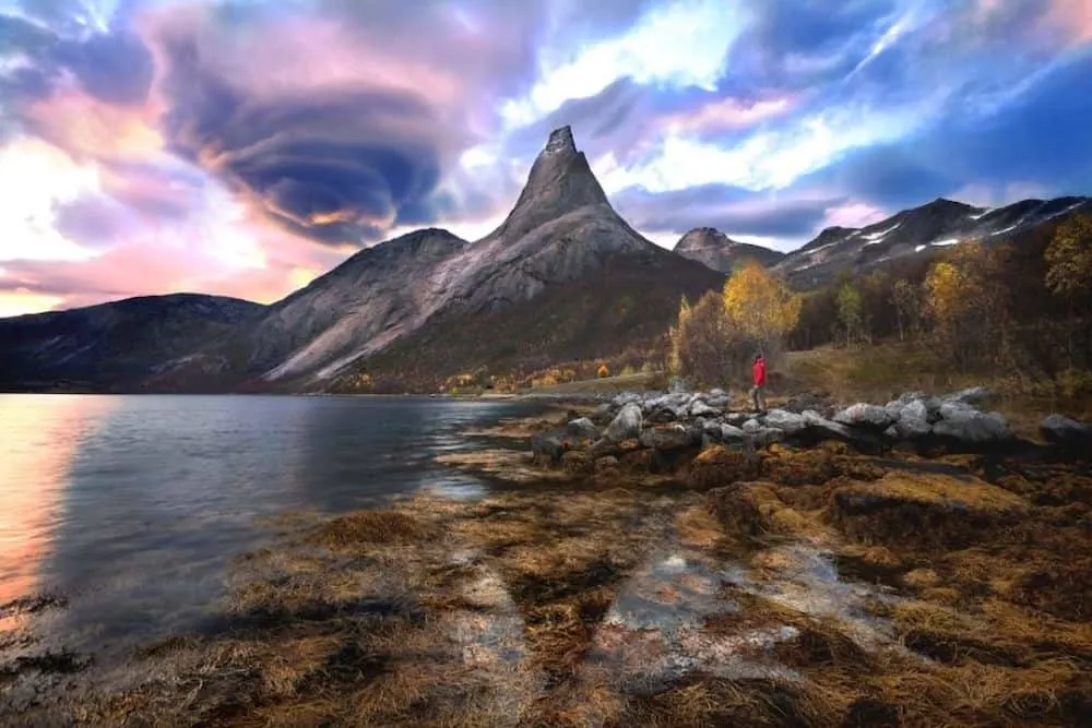
13. Måtinden and the Stave-Bleak Coastal Trail

Located on the Vesterlaen Islands in Northern Norway (right near the Lofoten Islands and Tromso), the hike up Måtinden and along the Stave-Bleak Coastal Trail is not to be missed.
I mean, not only is it a whole hell of a lot easier than many of the hikes on this list but you’ll also enjoy stunning views of the island’s western coast from the plateau at the top.
Also take some time to stop along the way and fully appreciate the wealth of gorgeous viewpoints here, like the one high above Høyvika beach.
Because this relatively easy trail is one of the best hikes in Norway for the entire family since it’s a well-defined path that starts off in a marshy area. You’ll then hit the steepest part of the climb and can use some of the rocks here to help you up.
After this, it’s a relatively flat and easy climb all the way up to Måtinden. And if you can, go around sunset since the views are extra special at this time of day.
Once at Måtinden, the trail ends with a vertical drop and is surrounded by several beaches, in addition to the cliffs of Pikstaven, Hegstaven, and Breistaven.
If you want, you can also hike this as an out and back trail from the trailhead on the road (to find it just Google “”Parking for Måtinden”), or out and back from Bleik. Alternatively, you could just hike this trail one way if you start at the trailhead on the road and end in Bleik or continue on and hike the entire coastal trail to Stave.
Pro Tip: Always come prepared and bring warm clothes/rain gear since it can cold and windy, even in the summer months. Also be sure to wear sturdy, waterproof hiking boots and check the weather since the summit can sometimes be covered with fog, making the views almost non-existent.
Length: 7.6 km (or 4.7 miles round trip to Måtinden and 9 km if you do the entire coastal trail)
Difficulty: Easy/Moderate
Elevation Gain: 420 meters (1,376 feet)
Time to Complete: Between 3 and 4 hours for the hike and then add on another 2 hours if you want to rock climb to the top of Svolvaergeita.
14. Segla

Meet Segla, the single most popular hike on the island of Segla.
And although this trek may only be 5 km long, don’t let the relatively short distance fool you into thinking it’s gonna be easy.
Because it’s not…especially the second half of the climb.
Yeah, it’s a very steep hike up the southern side of the mountain. Thankfully though, there’s not a ton of exposure so if you stay on the right side during your climb, you should be fine (the hike itself isn’t all that exciting but the view at the top is).
You’ll also want to be vigilant of rocks that have been loosened by other hikers since this is a very popular climb.
However, once at the top, you can admire the beautiful Mefjord and the surrounding mountain ranges – a sight that is especially gorgeous at sunset.
Although, you probably won’t be alone at the summit since basically everyone and their brother’s, sister’s cousin uses this trail (check out Barden and Keipen trails instead if you want a quieter experience).
You should also wear good hiking shoes and steer clear of this hike if it’s rainy or extra windy outside. .
Pro Tip: If you’re new to hiking, this may not be the climb for you. Because the real challenge begins on the second half of the climb when you begin to push to the summit. It’s extremely steep and there is really no paved trail to follow, even if the view is awesome.
Also, if you want that immortal shot of Segla, you’ll need to hike up the nearby mountain of Hesten.
Length: 5 km (3.1 miles round trip)
Difficulty: Moderate
Elevation Gain: 590 meters (1,937 feet)
Time to Complete: Between 3 and 4 hours.
15. Stetind

Located near Kjøpsvik, Nordland, Stetind is a much-beloved mountain (FYI, it’s actually the national mountain of Norway) that is home to some of the best hikes in Norway.
And although this mountain is pretty dang enchanting to anyone who sees it, this is one of those Norway hiking trails that is really only meant for very experienced hikers.
So yeah, you’ve been warned. But, if you’re up for a challenge, then you can do a beautiful two to three-hour hike through a local forest before hitting the base of the mountain.
Once here, you can choose to ascend the mountain using either the Normalveien or the Sydpillaren route.
For Normalveien, you’ll need a rack of cams and some ropes to make it to the top – a journey that is a fairly easy, 8-hour climb.
In particular, the finger traverse will be an especially difficult section of this trail. However, it is home to a wicked viewpoint so that makes the experience infinitely more enjoyable.
In contrast, the Sydpillaren route requires more advanced climbing experience and is a multi-pitch that takes between 8 and 12 hours to complete.
Because of its beauty though, it’s a really popular hike. Therefore, try and start early so you can (hopefully) have the mountain all to yourself.
Pro Tip: Weather in Northern Norway can change REALLY quickly. Therefore, pack enough clothing and gear for any and every type of weather imaginable.
Length: 10 km (or 6.2 miles round trip)
Difficulty: Difficult
Elevation Gain: 1258 meters (4,127 feet)
Time to Complete: Between 10 and 12 hours.
Additional Norway Travel Resources You’ll Love
- Norway Travel Guide: 18 BIG Mistakes to Avoid
- 20 of the Most Beautiful Places in Norway
- 20 Must-see Places in Europe this Winter
And so my fellow outdoor enthusiasts from all across the globe, that just about wraps about this epic post on 15 of the absolute best hikes in Norway!
So, did your favie fave Norway hiking trail make the list? If not then let me know in the comments below because I definitely want to check it out.
Plus, if you found this post helpful, then you should obviously pin it now so that you can read it again later!
Finally, please consider buying me a coffee. It’s a great way to say “thank you” for all the free content you receive. No amount is too small and anything you can give will be greatly appreciated.


